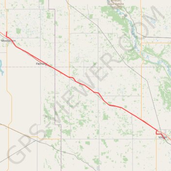
Import a GPX file

Moosomin - Virden

#Bike #Moosomin #Virden

  • Distance: 42.7 mi
  • Elevation gain: 34 m
  • Maximum elevation: 577 m
  • Elevation loss: 163 m
  • Minimum elevation: 441 m

Interactive trail map

Trail profile

  • Distance: 42.7 mi
  • Elevation gain: 34 m
  • Maximum elevation: 577 m
  • Elevation loss: 163 m
  • Minimum elevation: 441 m

About this trail

Name: Moosomin - Virden trail, distance, elevation, map, profile, GPS track

Start: Highway 8, Moosomin, Moosomin No. 121, Saskatchewan, S0G 3N0, Canada (50.17088 -101.67595)

End: Virden Collegiate Institute, 7 Avenue South, Virden, Manitoba, R0M 2C0, Canada (49.84253 -100.92445)

Coordinates: 49.84253 -101.67785 50.17088 -100.92359

Other hiking, mountain biking, running and outdoor activity trails

Click on a trail to view its statistics, map and profile.

Whitewood - Moosomin

Canada > Saskatchewan > Whitewood

#Bike #Whitewood #Moosomin

Distance: 31.1 mi • Elevation gain: 38 m • Maximum elevation: 602 m

Virden - Brandon

Canada > Virden

#Bike #Virden #Brandon

Distance: 49.5 mi • Elevation gain: 137 m • Maximum elevation: 446 m

Gear up for your next adventure:

🧣Neck Gaiters - Protects against wind and sun on exposed ridges and peaks
Lightweight Solo Tents - Backpacking tents designed for wild camping in the UK highlands
🚶Walking Pedometers - Simple distance tracking for casual trail walkers
🧼Technical Clothing Wash - Special soap to clean and restore waterproof membranes
🌂Windproof Trekking Umbrellas - Surprising but effective rain protection on low-wind trails

As an Amazon Associate, this site earns from qualifying purchases at no extra cost to you.