Import a GPX file

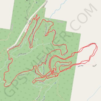
Ourimbah Mountain Bike Loop

Ourimbah State Forest. #MTB #Loop #Ourimbah

  • Distance: 6.5 mi
  • Elevation gain: 206 m
  • Maximum elevation: 87 m
  • Elevation loss: 206 m
  • Minimum elevation: 25 m

Interactive trail map

Trail profile

  • Distance: 6.5 mi
  • Elevation gain: 206 m
  • Maximum elevation: 87 m
  • Elevation loss: 206 m
  • Minimum elevation: 25 m

About this trail

Gear up for your next adventure:

🎒Hiking Daypacks - Compact backpacks ideal for short hikes and excursions
🧺Ultralight Dry Bags - Organize and waterproof your gear inside your rucksack
📐Altimeters & Barometers - Tools for measuring altitude and air pressure
🧴Sport Sunscreen Sticks - High-protection sunblock that won't run into your eyes on the trail
🧢Hiking Hats - Sun and weather protection for outdoor walks

As an Amazon Associate, this site earns from qualifying purchases at no extra cost to you.