Make a donation
Gear up for your next adventure:
As an Amazon Associate, this site earns from qualifying purchases at no extra cost to you.
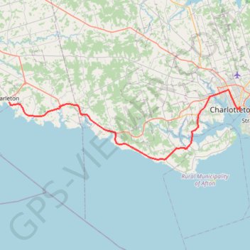
Borden-Charleton - Charlottetown
Prince Edward Island. #Bike #BordenCharleton #Charlottetown
- Distance: 37.1 mi
- Elevation gain: 386 m
- Maximum elevation: 39 m
- Elevation loss: 393 m
- Minimum elevation: 0 m
Interactive trail map
Make a donation
Gear up for your next adventure:
As an Amazon Associate, this site earns from qualifying purchases at no extra cost to you.
Trail profile
- Distance: 37.1 mi
- Elevation gain: 386 m
- Maximum elevation: 39 m
- Elevation loss: 393 m
- Minimum elevation: 0 m
Make a donation
Gear up for your next adventure:
As an Amazon Associate, this site earns from qualifying purchases at no extra cost to you.
About this trail
Name: Borden-Charleton - Charlottetown trail, distance, elevation, map, profile, GPS track
Coordinates: 46.15336 -63.66271 46.26660 -63.12053
Make a donation
Gear up for your next adventure:
As an Amazon Associate, this site earns from qualifying purchases at no extra cost to you.
Other hiking, mountain biking, running and outdoor activity trails
Click on a trail to view its statistics, map and profile.
Charlottetown to Stratford on bicycle
Canada > Prince Edward Island > Queens County > Charlottetown
Distance: 6.0 mi • Elevation gain: 51 m • Maximum elevation: 23 m
Borden-Carleton - Charlottetown
Canada > Prince Edward Island > Town of Borden-Carleton > Borden-Carleton
Prince Edward Island. #Bike #BordenCarleton #Charlottetown #PrinceEdward
Distance: 40.5 mi • Elevation gain: 364 m • Maximum elevation: 94 m