Thank you for supporting this site ❤️
Make a donation
Make a donation
Gear up for your next adventure:
As an Amazon Associate, this site earns from qualifying purchases at no extra cost to you.
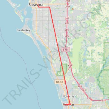
Legacy Trail, Sarasota to Venice Train Depot
- Distance: 40.2 mi
- Elevation gain: 77 m
- Maximum elevation: 16 m
- Elevation loss: 77 m
- Minimum elevation: -1 m
Interactive trail map
Thank you for supporting this site ❤️
Make a donation
Make a donation
Gear up for your next adventure:
As an Amazon Associate, this site earns from qualifying purchases at no extra cost to you.
Trail profile
- Distance: 40.2 mi
- Elevation gain: 77 m
- Maximum elevation: 16 m
- Elevation loss: 77 m
- Minimum elevation: -1 m
Thank you for supporting this site ❤️
Make a donation
Make a donation
Gear up for your next adventure:
As an Amazon Associate, this site earns from qualifying purchases at no extra cost to you.
About this trail
Name: Legacy Trail, Sarasota to Venice Train Depot trail, distance, elevation, map, profile, GPS track
Coordinates: 27.09842 -82.52568 27.33741 -82.43742
Thank you for supporting this site ❤️
Make a donation
Make a donation
Gear up for your next adventure:
As an Amazon Associate, this site earns from qualifying purchases at no extra cost to you.