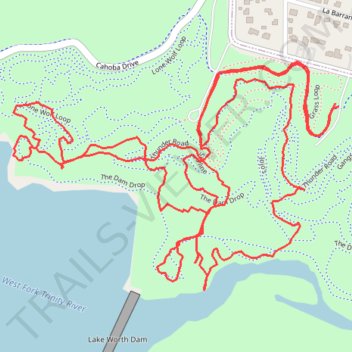
Hike at Marion Sansom Park
- Distance: 3.9 mi
- Elevation gain: 144 m
- Maximum elevation: 226 m
- Elevation loss: 144 m
- Minimum elevation: 168 m
- Moving time: 1 h 20 m
- Moving speed: 2.9 mph
- Maximum speed: 6.2 mph
- Total time: 1 h 23 m
- Global speed: 2.8 mph
Interactive trail map
Trail profile
- Distance: 3.9 mi
- Elevation gain: 144 m
- Maximum elevation: 226 m
- Elevation loss: 144 m
- Minimum elevation: 168 m
- Moving time: 1 h 20 m
- Moving speed: 2.9 mph
- Maximum speed: 6.2 mph
- Total time: 1 h 23 m
- Global speed: 2.8 mph
About this trail
Name: Hike at Marion Sansom Park trail, distance, elevation, map, profile, GPS track
Start: Grass Loop, Fort Worth, Tarrant County, Texas, 76127, United States (32.79592 -97.40906)
End: Grass Loop, Fort Worth, Tarrant County, Texas, 76127, United States (32.79598 -97.40916)
Coordinates: 32.79154 -97.41829 32.79698 -97.40906