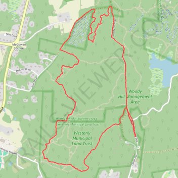
Merged hiking and biking trails, Woody Hill Managament Area
- Distance: 4.9 mi
- Elevation gain: 86 m
- Maximum elevation: 64 m
- Elevation loss: 86 m
- Minimum elevation: 20 m
- Moving time: 1 h 53 m
- Moving speed: 2.6 mph
- Maximum speed: 8.7 mph
- Total time: 2 h 35 m
- Global speed: 1.9 mph
Interactive trail map
Trail profile
- Distance: 4.9 mi
- Elevation gain: 86 m
- Maximum elevation: 64 m
- Elevation loss: 86 m
- Minimum elevation: 20 m
- Moving time: 1 h 53 m
- Moving speed: 2.6 mph
- Maximum speed: 8.7 mph
- Total time: 2 h 35 m
- Global speed: 1.9 mph
About this trail
Name: Merged hiking and biking trails, Woody Hill Managament Area trail, distance, elevation, map, profile, GPS track
Start: Woody Hill Road Exd, Westerly, South County, Rhode Island, 02808, United States (41.36913 -71.74484)
End: Woody Hill Road Exd, Westerly, South County, Rhode Island, 02808, United States (41.36916 -71.74490)
Coordinates: 41.36535 -71.75827 41.38330 -71.74481
Other hiking, mountain biking, running and outdoor activity trails
Click on a trail to view its statistics, map and profile.
Hiking trails in Woody Hill Management Area
United States > Rhode Island > South County > Westerly > Bradford
Distance: 5.2 mi • Elevation gain: 72 m • Maximum elevation: 56 m