
Pages Wood Loop Walk
- Distance: 3.7 mi
- Elevation gain: 71 m
- Maximum elevation: 56 m
- Elevation loss: 71 m
- Minimum elevation: 20 m
- Moving time: 1 h 12 m
- Moving speed: 3.1 mph
- Maximum speed: 4.0 mph
- Total time: 1 h 12 m
- Global speed: 3.1 mph
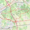
Interactive trail map
Trail profile
- Distance: 3.7 mi
- Elevation gain: 71 m
- Maximum elevation: 56 m
- Elevation loss: 71 m
- Minimum elevation: 20 m
- Moving time: 1 h 12 m
- Moving speed: 3.1 mph
- Maximum speed: 4.0 mph
- Total time: 1 h 12 m
- Global speed: 3.1 mph
About this trail
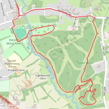
Name: Pages Wood Loop Walk trail, distance, elevation, map, profile, GPS track
Coordinates: 51.58089 0.23671 51.59188 0.25162
Topography: Greater London topographic map, elevation, terrain
Other hiking, mountain biking, running and outdoor activity trails
Click on a trail to view its statistics, map and profile.
Tyler's Common and Pages Wood Walk
United Kingdom > England > Greater London
Distance: 4.5 mi • Elevation gain: 106 m • Maximum elevation: 71 m
Harold Wood - Hornchurch Country Park - Corbets Tey - Folkes Lane Wood
United Kingdom > England > Greater London
Distance: 15.2 mi • Elevation gain: 183 m • Maximum elevation: 84 m
Harold Wood Park - Pages Wood
United Kingdom > England > Greater London
Distance: 4.1 mi • Elevation gain: 53 m • Maximum elevation: 37 m
Harold Wood - Cranham - Thorndon CP - Tylers Common
United Kingdom > England > Greater London
Distance: 12.1 mi • Elevation gain: 190 m • Maximum elevation: 118 m