Thank you for supporting this site ❤️
Make a donation
Make a donation
Gear up for your next adventure:
As an Amazon Associate, this site earns from qualifying purchases at no extra cost to you.
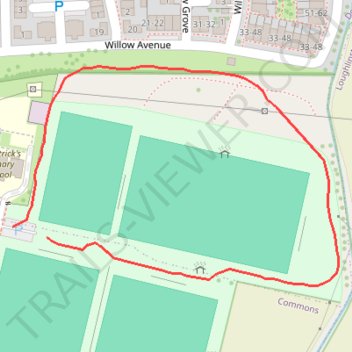
Celbridge GAA walkway
- Distance: 0.4 mi
- Elevation gain: 2 m
- Maximum elevation: 57 m
- Elevation loss: 2 m
- Minimum elevation: 55 m
- Moving time: 9 m 35 s
- Moving speed: 2.8 mph
- Maximum speed: 4.5 mph
- Total time: 9 m 35 s
- Global speed: 2.8 mph
Interactive trail map
Thank you for supporting this site ❤️
Make a donation
Make a donation
Gear up for your next adventure:
As an Amazon Associate, this site earns from qualifying purchases at no extra cost to you.
Trail profile
- Distance: 0.4 mi
- Elevation gain: 2 m
- Maximum elevation: 57 m
- Elevation loss: 2 m
- Minimum elevation: 55 m
- Moving time: 9 m 35 s
- Moving speed: 2.8 mph
- Maximum speed: 4.5 mph
- Total time: 9 m 35 s
- Global speed: 2.8 mph
Thank you for supporting this site ❤️
Make a donation
Make a donation
Gear up for your next adventure:
As an Amazon Associate, this site earns from qualifying purchases at no extra cost to you.
About this trail
Name: Celbridge GAA walkway trail, distance, elevation, map, profile, GPS track
Coordinates: 53.33169 -6.52825 53.33329 -6.52427
Thank you for supporting this site ❤️
Make a donation
Make a donation
Gear up for your next adventure:
As an Amazon Associate, this site earns from qualifying purchases at no extra cost to you.