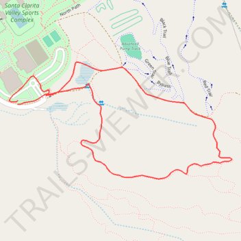
Santa Clarita Sports Complex Loop Trail
- Distance: 1.0 mi
- Elevation gain: 47 m
- Maximum elevation: 476 m
- Elevation loss: 48 m
- Minimum elevation: 427 m
- Moving time: 27 m 49 s
- Moving speed: 2.2 mph
- Maximum speed: 4.0 mph
- Total time: 32 m 57 s
- Global speed: 1.9 mph
Interactive trail map
Trail profile
- Distance: 1.0 mi
- Elevation gain: 47 m
- Maximum elevation: 476 m
- Elevation loss: 48 m
- Minimum elevation: 427 m
- Moving time: 27 m 49 s
- Moving speed: 2.2 mph
- Maximum speed: 4.0 mph
- Total time: 32 m 57 s
- Global speed: 1.9 mph
About this trail
Name: Santa Clarita Sports Complex Loop Trail trail, distance, elevation, map, profile, GPS track
Coordinates: 34.40780 -118.49972 34.41039 -118.49373
Other hiking, mountain biking, running and outdoor activity trails
Click on a trail to view its statistics, map and profile.
Area surrounding Bike Park of Santa Clarita
United States > California > Los Angeles County > Santa Clarita
Distance: 1.7 mi • Elevation gain: 86 m • Maximum elevation: 499 m