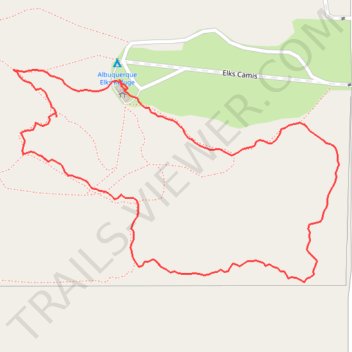
Albuquerque Elks Refuge
- Distance: 1.1 mi
- Elevation gain: 35 m
- Maximum elevation: 2,288 m
- Elevation loss: 35 m
- Minimum elevation: 2,255 m
- Moving time: 18 m 14 s
- Moving speed: 3.5 mph
- Maximum speed: 9.2 mph
- Total time: 20 m 29 s
- Global speed: 3.1 mph
Interactive trail map
Trail profile
- Distance: 1.1 mi
- Elevation gain: 35 m
- Maximum elevation: 2,288 m
- Elevation loss: 35 m
- Minimum elevation: 2,255 m
- Moving time: 18 m 14 s
- Moving speed: 3.5 mph
- Maximum speed: 9.2 mph
- Total time: 20 m 29 s
- Global speed: 3.1 mph
About this trail
Name: Albuquerque Elks Refuge trail, distance, elevation, map, profile, GPS track
Coordinates: 34.96803 -106.31983 34.97093 -106.31440