Heathcote - Miara - Depression Cave - Scouters
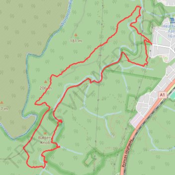
- Distance: 7.9 mi
- Elevation gain: 431 m
- Maximum elevation: 195 m
- Elevation loss: 431 m
- Minimum elevation: 44 m
- Moving time: 4 h 13 m
- Moving speed: 1.9 mph
- Maximum speed: 7.0 mph
- Total time: 6 h 16 m
- Global speed: 1.3 mph
Interactive trail map
Trail profile
- Distance: 7.9 mi
- Elevation gain: 431 m
- Maximum elevation: 195 m
- Elevation loss: 431 m
- Minimum elevation: 44 m
- Moving time: 4 h 13 m
- Moving speed: 1.9 mph
- Maximum speed: 7.0 mph
- Total time: 6 h 16 m
- Global speed: 1.3 mph
About this trail
Name: Heathcote - Miara - Depression Cave - Scouters trail, distance, elevation, map, profile, GPS track
Coordinates: -34.10523 150.97322 -34.07751 150.99991
Other hiking, mountain biking, running and outdoor activity trails
Click on a trail to view its statistics, map and profile.
Royal National Park Loop Ride between Heathcote and Waterfall
Australia > New South Wales > Sydney
Distance: 9.4 mi • Elevation gain: 224 m • Maximum elevation: 247 m
Royal National Park Ride between Waterfall and Heathcote
Australia > New South Wales > Sydney
Distance: 8.4 mi • Elevation gain: 156 m • Maximum elevation: 236 m
Waterfall Trail Run - Heathcote National Park
Australia > New South Wales > Sydney
Distance: 12.5 mi • Elevation gain: 521 m • Maximum elevation: 233 m