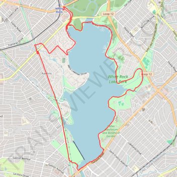
White Rock Lake Park
- Distance: 11.2 mi
- Elevation gain: 120 m
- Maximum elevation: 162 m
- Elevation loss: 120 m
- Minimum elevation: 130 m
- Moving time: 1 h 14 m
- Moving speed: 9.0 mph
- Maximum speed: 17.7 mph
- Total time: 1 h 36 m
- Global speed: 6.9 mph
Interactive trail map
Trail profile
- Distance: 11.2 mi
- Elevation gain: 120 m
- Maximum elevation: 162 m
- Elevation loss: 120 m
- Minimum elevation: 130 m
- Moving time: 1 h 14 m
- Moving speed: 9.0 mph
- Maximum speed: 17.7 mph
- Total time: 1 h 36 m
- Global speed: 6.9 mph
About this trail
Name: White Rock Lake Park trail, distance, elevation, map, profile, GPS track
Start: West Lawther Drive, Dallas, Dallas County, Texas, 75214, United States (32.85454 -96.73167)
End: West Lawther Drive, Dallas, Dallas County, Texas, 75214, United States (32.85453 -96.73159)
Coordinates: 32.81307 -96.74040 32.85542 -96.70711
Other hiking, mountain biking, running and outdoor activity trails
Click on a trail to view its statistics, map and profile.
White Rock Creek Trail up to Northaven Trail
United States > Texas > Dallas County > Dallas
Distance: 6.7 mi • Elevation gain: 75 m • Maximum elevation: 176 m
White Rock Lake Loop
United States > Texas > Dallas County > Dallas
Distance: 9.0 mi • Elevation gain: 78 m • Maximum elevation: 153 m
Cycling in Dallas and Park Cities
United States > Texas > Dallas County > Dallas > Gifford
Distance: 26.8 mi • Elevation gain: 281 m • Maximum elevation: 195 m