Make a donation
Gear up for your next adventure:
As an Amazon Associate, this site earns from qualifying purchases at no extra cost to you.
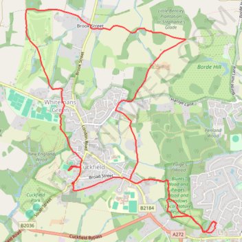
Loop Walk - Haywards Heath, Borde Hill, Cuckfield, Whitemans Green
- Distance: 7.9 mi
- Elevation gain: 190 m
- Maximum elevation: 127 m
- Elevation loss: 190 m
- Minimum elevation: 59 m
- Moving time: 3 h 8 m
- Moving speed: 2.5 mph
- Maximum speed: 4.9 mph
- Total time: 4 h 2 m
- Global speed: 2.0 mph
Interactive trail map
Make a donation
Gear up for your next adventure:
As an Amazon Associate, this site earns from qualifying purchases at no extra cost to you.
Trail profile
- Distance: 7.9 mi
- Elevation gain: 190 m
- Maximum elevation: 127 m
- Elevation loss: 190 m
- Minimum elevation: 59 m
- Moving time: 3 h 8 m
- Moving speed: 2.5 mph
- Maximum speed: 4.9 mph
- Total time: 4 h 2 m
- Global speed: 2.0 mph
Make a donation
Gear up for your next adventure:
As an Amazon Associate, this site earns from qualifying purchases at no extra cost to you.
About this trail
Name: Loop Walk - Haywards Heath, Borde Hill, Cuckfield, Whitemans Green trail, distance, elevation, map, profile, GPS track
Coordinates: 51.00004 -0.15197 51.02626 -0.11645
Topography: Mid Sussex topographic map, elevation, terrain
Make a donation
Gear up for your next adventure:
As an Amazon Associate, this site earns from qualifying purchases at no extra cost to you.
Other hiking, mountain biking, running and outdoor activity trails
Click on a trail to view its statistics, map and profile.
Walk - Cuckfield, Bolney
United Kingdom > England > West Sussex > Mid Sussex > Cuckfield
Cuckfield, Bolney
Distance: 9.1 mi • Elevation gain: 227 m • Maximum elevation: 104 m
Walk - Haywards Heath, Borde Hill, Brook Street, Cuckfield
United Kingdom > England > West Sussex > Mid Sussex > Haywards Heath
Distance: 7.6 mi • Elevation gain: 197 m • Maximum elevation: 127 m
Walk - Handcross, Nymans, Staplefield, Whitmans Green, Cuckfield, Haywards Heath
United Kingdom > England > West Sussex > Mid Sussex > Slaugham
Distance: 7.3 mi • Elevation gain: 162 m • Maximum elevation: 151 m
Walk - Handcross, Cuckfield, Haywards Heath
United Kingdom > England > West Sussex > Mid Sussex > Slaugham
Handcross, Cuckfield, Haywards Heath
Distance: 7.8 mi • Elevation gain: 169 m • Maximum elevation: 154 m
Make a donation
Gear up for your next adventure:
As an Amazon Associate, this site earns from qualifying purchases at no extra cost to you.
Walk - Handcross, Nymans, Staplefield, Whitmans Green, Cuckfield, Haywards Heath
United Kingdom > England > West Sussex > Mid Sussex > Slaugham
Distance: 8.4 mi • Elevation gain: 202 m • Maximum elevation: 153 m
Loop walk - Haywards Heath, Borde Hill, Cuckfield, Whitemans Green
United Kingdom > England > West Sussex > Mid Sussex > Haywards Heath
Distance: 7.6 mi • Elevation gain: 185 m • Maximum elevation: 127 m
Walk - Haywards Heath, Borde Hill, Cuckfield, Whitemans Green
United Kingdom > England > West Sussex > Mid Sussex > Haywards Heath
Distance: 6.9 mi • Elevation gain: 187 m • Maximum elevation: 127 m
Walk - Nymans, Handcross, Staplefield, Cuckfield, Haywards Heath
United Kingdom > England > West Sussex > Mid Sussex > Slaugham
Distance: 8.7 mi • Elevation gain: 183 m • Maximum elevation: 152 m
Make a donation
Gear up for your next adventure:
As an Amazon Associate, this site earns from qualifying purchases at no extra cost to you.