Thank you for supporting this site ❤️
Make a donation
Make a donation
Gear up for your next adventure:
As an Amazon Associate, this site earns from qualifying purchases at no extra cost to you.
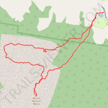
Mount Maroon up North West via Cave
- Distance: 4.3 mi
- Elevation gain: 769 m
- Maximum elevation: 942 m
- Elevation loss: 769 m
- Minimum elevation: 359 m
- Moving time: 3 h 31 m
- Moving speed: 1.2 mph
- Maximum speed: 4.3 mph
- Total time: 5 h 46 m
- Global speed: 0.7 mph
Interactive trail map
Thank you for supporting this site ❤️
Make a donation
Make a donation
Gear up for your next adventure:
As an Amazon Associate, this site earns from qualifying purchases at no extra cost to you.
Trail profile
- Distance: 4.3 mi
- Elevation gain: 769 m
- Maximum elevation: 942 m
- Elevation loss: 769 m
- Minimum elevation: 359 m
- Moving time: 3 h 31 m
- Moving speed: 1.2 mph
- Maximum speed: 4.3 mph
- Total time: 5 h 46 m
- Global speed: 0.7 mph
Thank you for supporting this site ❤️
Make a donation
Make a donation
Gear up for your next adventure:
As an Amazon Associate, this site earns from qualifying purchases at no extra cost to you.
About this trail
Name: Mount Maroon up North West via Cave trail, distance, elevation, map, profile, GPS track
Start: Mt Maroon Summit Route, Maroon, Scenic Rim Regional, Queensland, Australia (-28.19624 152.74070)
End: Mt Maroon Summit Route, Maroon, Scenic Rim Regional, Queensland, Australia (-28.19628 152.74056)
Coordinates: -28.20939 152.72272 -28.19621 152.74070
Thank you for supporting this site ❤️
Make a donation
Make a donation
Gear up for your next adventure:
As an Amazon Associate, this site earns from qualifying purchases at no extra cost to you.