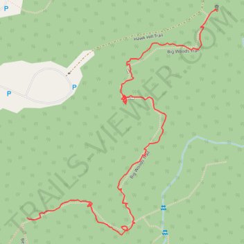
Big Woods Trail to the tower
- Distance: 0.8 mi
- Elevation gain: 4 m
- Maximum elevation: 204 m
- Elevation loss: 16 m
- Minimum elevation: 191 m
- Moving time: 35 m 8 s
- Moving speed: 1.4 mph
- Maximum speed: 5.4 mph
- Total time: 42 m 45 s
- Global speed: 1.2 mph
Interactive trail map
Trail profile
- Distance: 0.8 mi
- Elevation gain: 4 m
- Maximum elevation: 204 m
- Elevation loss: 16 m
- Minimum elevation: 191 m
- Moving time: 35 m 8 s
- Moving speed: 1.4 mph
- Maximum speed: 5.4 mph
- Total time: 42 m 45 s
- Global speed: 1.2 mph
About this trail
Name: Big Woods Trail to the tower trail, distance, elevation, map, profile, GPS track
Start: Beech Grove Trail, Vermilion County, Illinois, United States (40.00970 -87.55694)
End: Big Woods Trail, Vermilion County, Illinois, United States (40.01390 -87.55187)
Coordinates: 40.00935 -87.55694 40.01395 -87.55187