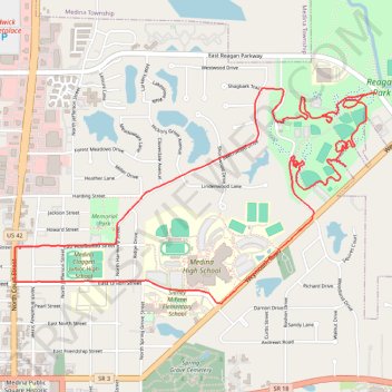
Medina Reagan Park Trail
- Distance: 5.4 mi
- Elevation gain: 56 m
- Maximum elevation: 323 m
- Elevation loss: 56 m
- Minimum elevation: 281 m
- Moving time: 1 h 1 m
- Moving speed: 5.3 mph
- Maximum speed: 8.7 mph
- Total time: 1 h 3 m
- Global speed: 5.1 mph
Interactive trail map
Trail profile
- Distance: 5.4 mi
- Elevation gain: 56 m
- Maximum elevation: 323 m
- Elevation loss: 56 m
- Minimum elevation: 281 m
- Moving time: 1 h 1 m
- Moving speed: 5.3 mph
- Maximum speed: 8.7 mph
- Total time: 1 h 3 m
- Global speed: 5.1 mph
About this trail
Name: Medina Reagan Park Trail trail, distance, elevation, map, profile, GPS track
Start: 126, East Homestead Street, Medina, Medina County, Ohio, 44256, United States (41.14607 -81.86354)
End: 132, East Homestead Street, Medina, Medina County, Ohio, 44256, United States (41.14620 -81.86347)
Coordinates: 41.14314 -81.86390 41.15473 -81.83799