Thank you for supporting this site ❤️
Make a donation
Make a donation
Gear up for your next adventure:
As an Amazon Associate, this site earns from qualifying purchases at no extra cost to you.
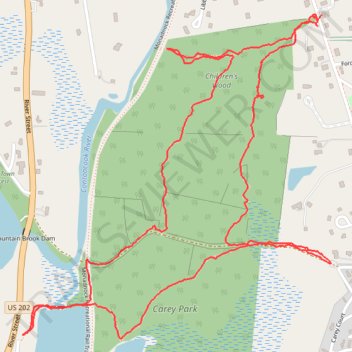
Children's woods - Contoocook Lake Dam
- Distance: 2.8 mi
- Elevation gain: 100 m
- Maximum elevation: 350 m
- Elevation loss: 100 m
- Minimum elevation: 308 m
- Moving time: 1 h 20 m
- Moving speed: 2.1 mph
- Maximum speed: 17.1 mph
- Total time: 1 h 25 m
- Global speed: 1.9 mph
Interactive trail map
Thank you for supporting this site ❤️
Make a donation
Make a donation
Gear up for your next adventure:
As an Amazon Associate, this site earns from qualifying purchases at no extra cost to you.
Trail profile
- Distance: 2.8 mi
- Elevation gain: 100 m
- Maximum elevation: 350 m
- Elevation loss: 100 m
- Minimum elevation: 308 m
- Moving time: 1 h 20 m
- Moving speed: 2.1 mph
- Maximum speed: 17.1 mph
- Total time: 1 h 25 m
- Global speed: 1.9 mph
Thank you for supporting this site ❤️
Make a donation
Make a donation
Gear up for your next adventure:
As an Amazon Associate, this site earns from qualifying purchases at no extra cost to you.
About this trail
Name: Children's woods - Contoocook Lake Dam trail, distance, elevation, map, profile, GPS track
Coordinates: 42.80049 -72.02864 42.80866 -72.01803
Thank you for supporting this site ❤️
Make a donation
Make a donation
Gear up for your next adventure:
As an Amazon Associate, this site earns from qualifying purchases at no extra cost to you.