Thank you for supporting this site ❤️
Make a donation
Make a donation
Gear up for your next adventure:
As an Amazon Associate, this site earns from qualifying purchases at no extra cost to you.
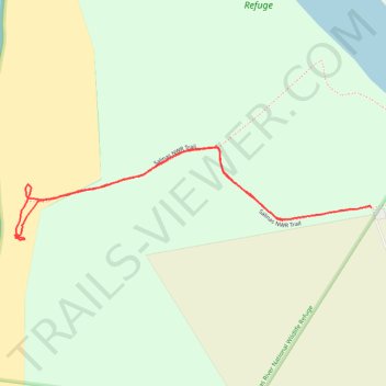
Salinas River National Wildlife Refuge
- Distance: 1.6 mi
- Elevation gain: 5 m
- Maximum elevation: 3 m
- Elevation loss: 4 m
- Minimum elevation: -1 m
- Moving time: 45 m 27 s
- Moving speed: 2.2 mph
- Maximum speed: 3.7 mph
- Total time: 1 h 34 m
- Global speed: 1.1 mph
Interactive trail map
Thank you for supporting this site ❤️
Make a donation
Make a donation
Gear up for your next adventure:
As an Amazon Associate, this site earns from qualifying purchases at no extra cost to you.
Trail profile
- Distance: 1.6 mi
- Elevation gain: 5 m
- Maximum elevation: 3 m
- Elevation loss: 4 m
- Minimum elevation: -1 m
- Moving time: 45 m 27 s
- Moving speed: 2.2 mph
- Maximum speed: 3.7 mph
- Total time: 1 h 34 m
- Global speed: 1.1 mph
Thank you for supporting this site ❤️
Make a donation
Make a donation
Gear up for your next adventure:
As an Amazon Associate, this site earns from qualifying purchases at no extra cost to you.
About this trail
Name: Salinas River National Wildlife Refuge trail, distance, elevation, map, profile, GPS track
Start: Salinas NWR Trail, Monterey County, California, United States (36.73448 -121.79699)
End: Salinas NWR Trail, Monterey County, California, United States (36.73482 -121.79396)
Coordinates: 36.73395 -121.80615 36.73652 -121.79396
Thank you for supporting this site ❤️
Make a donation
Make a donation
Gear up for your next adventure:
As an Amazon Associate, this site earns from qualifying purchases at no extra cost to you.