Make a donation
Gear up for your next adventure:
As an Amazon Associate, this site earns from qualifying purchases at no extra cost to you.
Watchman
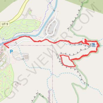
Interactive trail map
Make a donation
Gear up for your next adventure:
As an Amazon Associate, this site earns from qualifying purchases at no extra cost to you.
Trail profile
- Distance: 3.1 mi
- Elevation gain: 239 m
- Maximum elevation: 1,357 m
- Elevation loss: 239 m
- Minimum elevation: 1,199 m
Make a donation
Gear up for your next adventure:
As an Amazon Associate, this site earns from qualifying purchases at no extra cost to you.
About this trail
Name: Watchman trail, distance, elevation, map, profile, GPS track
Start: Watchman Trail, Washington County, Utah, 84767, United States (37.20090 -112.98580)
End: Watchman Trail, Washington County, Utah, 84767, United States (37.20090 -112.98580)
Coordinates: 37.19870 -112.98652 37.20231 -112.97242
Make a donation
Gear up for your next adventure:
As an Amazon Associate, this site earns from qualifying purchases at no extra cost to you.
Other hiking, mountain biking, running and outdoor activity trails
Click on a trail to view its statistics, map and profile.
Watchman Overlook Trail in Zion National Park
United States > Utah > Washington County
The Watchman Overlook Trail provides a moderate hike with rewarding views of iconic landmarks in the park. As you ascend from the Visitor Center, the trail offers vistas of the Virgin River and surrounding peaks like The Watchman, West Temple, and Bridge Mountain. The summit presents a dramatic overlook of…
Distance: 3.1 mi • Elevation gain: 288 m • Maximum elevation: 1,356 m
Pa'rus Trail in Zion National Park
United States > Utah > Washington County > Springdale
The Pa'rus Trail in Zion National Park offers a leisurely walk along the Virgin River, providing panoramic views of the towering sandstone cliffs, including the iconic Watchman peak. As you stroll, you'll encounter lush meadows, cross charming footbridges, and have opportunities to observe local wildlife. The…
Distance: 3.3 mi • Elevation gain: 60 m • Maximum elevation: 1,237 m
Watchman Trail in Zion National Park
United States > Utah > Washington County > Springdale
The Watchman Trail takes you on a gentle climb through stunning scenery, where you’ll find yourself surrounded by towering cliffs and vibrant landscapes. As you make your way to the outlook plateau, the views open up, revealing a breathtaking panorama of the Springdale area and the majestic Bridge Mountain.…
Distance: 3.7 mi • Elevation gain: 270 m • Maximum elevation: 1,358 m
Make a donation
Gear up for your next adventure:
As an Amazon Associate, this site earns from qualifying purchases at no extra cost to you.