Make a donation
Gear up for your next adventure:
As an Amazon Associate, this site earns from qualifying purchases at no extra cost to you.
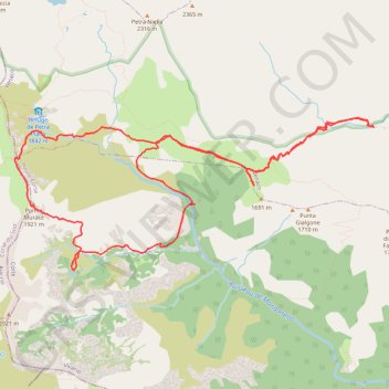
Etang de Gialicatapiano depuis le Verghello
- Distance: 10.4 mi
- Elevation gain: 1,486 m
- Maximum elevation: 1,892 m
- Elevation loss: 1,498 m
- Minimum elevation: 1,056 m
Interactive trail map
Make a donation
Gear up for your next adventure:
As an Amazon Associate, this site earns from qualifying purchases at no extra cost to you.
Trail profile
- Distance: 10.4 mi
- Elevation gain: 1,486 m
- Maximum elevation: 1,892 m
- Elevation loss: 1,498 m
- Minimum elevation: 1,056 m
Make a donation
Gear up for your next adventure:
As an Amazon Associate, this site earns from qualifying purchases at no extra cost to you.
About this trail
Name: Etang de Gialicatapiano depuis le Verghello trail, distance, elevation, map, profile, GPS track
Start: D 723, Venaco, Corte, Haute-Corse, Corsica, Metropolitan France, 20231, France (42.19628 9.10237)
End: D 723, Venaco, Corte, Haute-Corse, Corsica, Metropolitan France, 20231, France (42.19644 9.10221)
Coordinates: 42.18043 9.04900 42.19730 9.10237
Make a donation
Gear up for your next adventure:
As an Amazon Associate, this site earns from qualifying purchases at no extra cost to you.
Other hiking, mountain biking, running and outdoor activity trails
Click on a trail to view its statistics, map and profile.
00. GR 20 - Sud - Nord on GPSies.com
France > Corsica > South Corsica > Conca > Pianiccia
00. GR 20 - Sud - Nord
Distance: 109.5 mi • Elevation gain: 12,910 m • Maximum elevation: 2,243 m
1 LUCENA - MONTPELLIER
Distance: 1,842.0 mi • Elevation gain: 29,500 m • Maximum elevation: 1,048 m