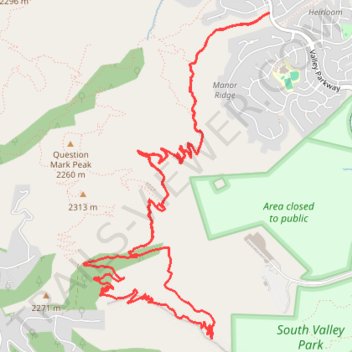
Thank you for supporting this site ❤️
Make a donation
Make a donation
Gear up for your next adventure:
As an Amazon Associate, this site earns from qualifying purchases at no extra cost to you.
Wildcat loop trail
- Distance: 9.9 mi
- Elevation gain: 666 m
- Maximum elevation: 2,251 m
- Elevation loss: 666 m
- Minimum elevation: 1,855 m
- Moving time: 1 h 53 m
- Moving speed: 5.2 mph
- Maximum speed: 10.1 mph
- Total time: 1 h 53 m
- Global speed: 5.2 mph
Interactive trail map
Thank you for supporting this site ❤️
Make a donation
Make a donation
Gear up for your next adventure:
As an Amazon Associate, this site earns from qualifying purchases at no extra cost to you.
Trail profile
- Distance: 9.9 mi
- Elevation gain: 666 m
- Maximum elevation: 2,251 m
- Elevation loss: 666 m
- Minimum elevation: 1,855 m
- Moving time: 1 h 53 m
- Moving speed: 5.2 mph
- Maximum speed: 10.1 mph
- Total time: 1 h 53 m
- Global speed: 5.2 mph
Thank you for supporting this site ❤️
Make a donation
Make a donation
Gear up for your next adventure:
As an Amazon Associate, this site earns from qualifying purchases at no extra cost to you.
About this trail
Name: Wildcat loop trail trail, distance, elevation, map, profile, GPS track
Coordinates: 39.54904 -105.18203 39.57477 -105.16292
Thank you for supporting this site ❤️
Make a donation
Make a donation
Gear up for your next adventure:
As an Amazon Associate, this site earns from qualifying purchases at no extra cost to you.