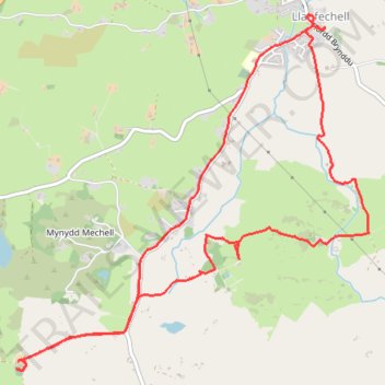
Isle of Anglesey Walking - Llanfechell Loop
- Distance: 5.5 mi
- Elevation gain: 89 m
- Maximum elevation: 71 m
- Elevation loss: 89 m
- Minimum elevation: 28 m
- Moving time: 2 h 31 m
- Moving speed: 2.2 mph
- Maximum speed: 3.5 mph
- Total time: 3 h 20 m
- Global speed: 1.6 mph
Interactive trail map
Trail profile
- Distance: 5.5 mi
- Elevation gain: 89 m
- Maximum elevation: 71 m
- Elevation loss: 89 m
- Minimum elevation: 28 m
- Moving time: 2 h 31 m
- Moving speed: 2.2 mph
- Maximum speed: 3.5 mph
- Total time: 3 h 20 m
- Global speed: 1.6 mph
About this trail
Name: Isle of Anglesey Walking - Llanfechell Loop trail, distance, elevation, map, profile, GPS track
Coordinates: 53.37237 -4.48245 53.39308 -4.44818
Topography: Isle of Anglesey topographic map, elevation, terrain