Import a GPX file

Rottnest Island - City of York Circuit

#Hiking #Loop #Rottnest

  • Distance: 5.1 mi
  • Elevation gain: 106 m
  • Maximum elevation: 31 m
  • Elevation loss: 106 m
  • Minimum elevation: 0 m

Interactive trail map

Trail profile

  • Distance: 5.1 mi
  • Elevation gain: 106 m
  • Maximum elevation: 31 m
  • Elevation loss: 106 m
  • Minimum elevation: 0 m

About this trail

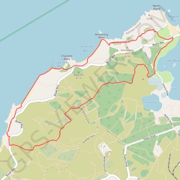
Name: Rottnest Island - City of York Circuit trail, distance, elevation, map, profile, GPS track

Start: Bovell Way, Rottnest Island, Geordie Bay, City of Cockburn, Western Australia, 6161, Australia (-31.99126 115.51497)

End: Gabbi Karniny Bidi, Rottnest Island, Geordie Bay, City of Cockburn, Western Australia, 6161, Australia (-31.99131 115.51496)

Coordinates: -32.00721 115.48715 -31.99011 115.51497

Other hiking, mountain biking, running and outdoor activity trails

Click on a trail to view its statistics, map and profile.

Rottnest Island Loop

Australia > Western Australia > The Settlement

#Bike #Loop #Rottnest

Distance: 11.9 mi • Elevation gain: 169 m • Maximum elevation: 26 m

Rottnest Island Mountain Biking Loop

Australia > Western Australia > The Settlement

Distance: 24.2 mi • Elevation gain: 355 m • Maximum elevation: 27 m

Gear up for your next adventure:

📷Outdoor Action Cameras - Cameras designed for hiking and adventure
👟Men's Trail Running Shoes - Lightweight grip for fast movement over topographic contours
Lightweight Tents - Compact tents for backpacking and trekking
🐕Hiking Dog Harnesses - Rugged harnesses for taking your companion on mountain trails
🛌Sleeping Bags - Warm and packable sleeping bags for outdoor nights

As an Amazon Associate, this site earns from qualifying purchases at no extra cost to you.