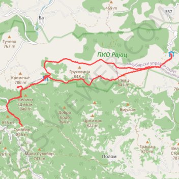
Rajac- Od Doma do Suvobora do Rajca
- Distance: 10.6 mi
- Elevation gain: 591 m
- Maximum elevation: 848 m
- Elevation loss: 582 m
- Minimum elevation: 625 m
- Moving time: 4 h 22 m
- Moving speed: 2.4 mph
- Maximum speed: 17.3 mph
- Total time: 5 h 58 m
- Global speed: 1.8 mph
Interactive trail map
Trail profile
- Distance: 10.6 mi
- Elevation gain: 591 m
- Maximum elevation: 848 m
- Elevation loss: 582 m
- Minimum elevation: 625 m
- Moving time: 4 h 22 m
- Moving speed: 2.4 mph
- Maximum speed: 17.3 mph
- Total time: 5 h 58 m
- Global speed: 1.8 mph
About this trail
Name: Rajac- Od Doma do Suvobora do Rajca trail, distance, elevation, map, profile, GPS track
Coordinates: 44.12103 20.17542 44.14284 20.24539
Other hiking, mountain biking, running and outdoor activity trails
Click on a trail to view its statistics, map and profile.
Rajac - Šiljak - Suvobor - Rajac
Serbia > Moravica Administrative District > Gornji Milanovac Municipality > Polom > Рајац
https://en-bw.trails-viewer.com/trail-xnx57/Rajac-Šiljak-Suvobor-Rajac/
Distance: 12.7 mi • Elevation gain: 677 m • Maximum elevation: 848 m
Rajac - Šiljak - Suvobor - Rajac
Serbia > Central Serbia > Moravica Administrative District > Gornji Milanovac Municipality > Polom > Рајац
Distance: 12.7 mi • Elevation gain: 667 m • Maximum elevation: 848 m
2022_Yu
Slovenia > Ajdovščina > Žapuže
Distance: 1,526.9 mi • Elevation gain: 32,048 m • Maximum elevation: 1,950 m
Ex. 'Lovačke priče' - Ravna reka - Dobra voda - Rajac vrh
Serbia > Central Serbia > Moravica Administrative District > Gornji Milanovac Municipality > Polom > Рајац
Distance: 10.1 mi • Elevation gain: 570 m • Maximum elevation: 843 m
Trenutna aktivnost: 10 LIP 2023 08:53
Serbia > Central Serbia > Kolubara Administrative District > Ljig Municipality > Slavkovica > Рајац
Distance: 4.8 mi • Elevation gain: 398 m • Maximum elevation: 847 m
Divčibare-Rior-Mokra pećina-Ravna planina-Suvobor-Rajac
Serbia > Central Serbia > Kolubara Administrative District > Divcibare
Distance: 16.6 mi • Elevation gain: 826 m • Maximum elevation: 1,020 m