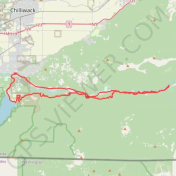
Chilliwack River Valley Trans Canada Trail (TCT)
- Distance: 36.1 mi
- Elevation gain: 1,276 m
- Maximum elevation: 373 m
- Elevation loss: 1,277 m
- Minimum elevation: 32 m
- Moving time: 3 h 52 m
- Moving speed: 9.3 mph
- Maximum speed: 33.7 mph
- Total time: 4 h 13 m
- Global speed: 8.5 mph
Interactive trail map
Trail profile
- Distance: 36.1 mi
- Elevation gain: 1,276 m
- Maximum elevation: 373 m
- Elevation loss: 1,277 m
- Minimum elevation: 32 m
- Moving time: 3 h 52 m
- Moving speed: 9.3 mph
- Maximum speed: 33.7 mph
- Total time: 4 h 13 m
- Global speed: 8.5 mph
About this trail
Name: Chilliwack River Valley Trans Canada Trail (TCT) trail, distance, elevation, map, profile, GPS track
Coordinates: 49.06385 -121.98116 49.09843 -121.69442
Other hiking, mountain biking, running and outdoor activity trails
Click on a trail to view its statistics, map and profile.
Chilliwack - Hope
Canada > British Columbia > Fraser Valley Regional District > Chilliwack
Fraser River. #Bike
Distance: 41.6 mi • Elevation gain: 526 m • Maximum elevation: 88 m