Thank you for supporting this site ❤️
Make a donation
Make a donation
Gear up for your next adventure:
As an Amazon Associate, this site earns from qualifying purchases at no extra cost to you.
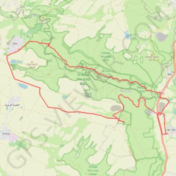
נווה אור - כוכב הירדן - נחל תבור
- Distance: 21.6 mi
- Elevation gain: 692 m
- Maximum elevation: 291 m
- Elevation loss: 691 m
- Minimum elevation: -242 m
Interactive trail map
Thank you for supporting this site ❤️
Make a donation
Make a donation
Gear up for your next adventure:
As an Amazon Associate, this site earns from qualifying purchases at no extra cost to you.
Trail profile
- Distance: 21.6 mi
- Elevation gain: 692 m
- Maximum elevation: 291 m
- Elevation loss: 691 m
- Minimum elevation: -242 m
Thank you for supporting this site ❤️
Make a donation
Make a donation
Gear up for your next adventure:
As an Amazon Associate, this site earns from qualifying purchases at no extra cost to you.
About this trail
Name: נווה אור - כוכב הירדן - נחל תבור trail, distance, elevation, map, profile, GPS track
Coordinates: 32.58594 35.44117 32.63952 35.55230
Thank you for supporting this site ❤️
Make a donation
Make a donation
Gear up for your next adventure:
As an Amazon Associate, this site earns from qualifying purchases at no extra cost to you.