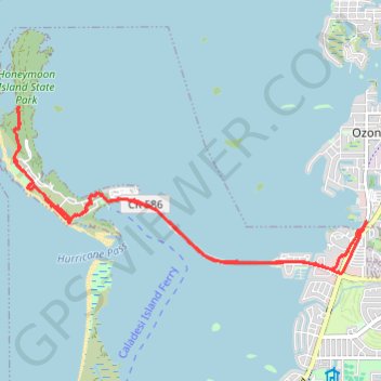
Import a GPX file

Honeymoon Island

Honeymoon Island State Park #Bike #Sea #Island #Park #Nature

  • Distance: 10.5 mi
  • Elevation gain: 49 m
  • Maximum elevation: 7 m
  • Elevation loss: 49 m
  • Minimum elevation: -1 m
  • Moving time: 1 h 16 m
  • Moving speed: 8.3 mph
  • Maximum speed: 16.8 mph
  • Total time: 1 h 25 m
  • Global speed: 7.4 mph

Interactive trail map

Trail profile

  • Distance: 10.5 mi
  • Elevation gain: 49 m
  • Maximum elevation: 7 m
  • Elevation loss: 49 m
  • Minimum elevation: -1 m
  • Moving time: 1 h 16 m
  • Moving speed: 8.3 mph
  • Maximum speed: 16.8 mph
  • Total time: 1 h 25 m
  • Global speed: 7.4 mph

About this trail

Name: Honeymoon Island trail, distance, elevation, map, profile, GPS track

Start: Pinellas Trail, Dunedin, Pinellas County, Florida, 34660, United States (28.05540 -82.77740)

End: Pinellas Trail, Dunedin, Pinellas County, Florida, 34660, United States (28.05538 -82.77741)

Coordinates: 28.04955 -82.83216 28.07300 -82.77619

Gear up for your next adventure:

👟Waterproof Leg Gaiters - Keep mud and water out of your boots in boggy terrain
🗺️Ordnance Survey Maps - Official UK maps for walking and outdoor activities
🥾Trekking Poles - Poles to improve stability on uneven terrain
🎒Multi-day Trekking Packs - Large capacity backpacks for wild camping and long-distance trails
🎒Replacement Sternum Straps - Repair parts for hiking rucksacks

As an Amazon Associate, this site earns from qualifying purchases at no extra cost to you.