Kallang River
- Distance: 1.9 mi
- Elevation gain: 30 m
- Maximum elevation: 14 m
- Elevation loss: 31 m
- Minimum elevation: 4 m
- Moving time: 21 m 22 s
- Moving speed: 5.5 mph
- Maximum speed: 7.5 mph
- Total time: 21 m 22 s
- Global speed: 5.5 mph
Interactive trail map
Trail profile
- Distance: 1.9 mi
- Elevation gain: 30 m
- Maximum elevation: 14 m
- Elevation loss: 31 m
- Minimum elevation: 4 m
- Moving time: 21 m 22 s
- Moving speed: 5.5 mph
- Maximum speed: 7.5 mph
- Total time: 21 m 22 s
- Global speed: 5.5 mph
About this trail
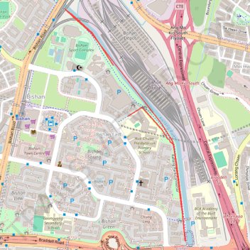
Name: Kallang River trail, distance, elevation, map, profile, GPS track
Coordinates: 1.34391 103.85060 1.35674 103.85728
Other hiking, mountain biking, running and outdoor activity trails
Click on a trail to view its statistics, map and profile.
Directions from Duck Tour Ramp to Marina Boulevard, Singapore
Distance: 65.5 mi • Elevation gain: 812 m • Maximum elevation: 51 m