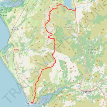
Rhinog Traverse from Trawsfynydd to Barmouth
- Distance: 23.6 mi
- Elevation gain: 1,977 m
- Maximum elevation: 755 m
- Elevation loss: 2,165 m
- Minimum elevation: 13 m
- Moving time: 10 h 19 m
- Moving speed: 2.3 mph
- Maximum speed: 6.9 mph
- Total time: 1 d 21 h
- Global speed: 0.5 mph
Interactive trail map
Trail profile
- Distance: 23.6 mi
- Elevation gain: 1,977 m
- Maximum elevation: 755 m
- Elevation loss: 2,165 m
- Minimum elevation: 13 m
- Moving time: 10 h 19 m
- Moving speed: 2.3 mph
- Maximum speed: 6.9 mph
- Total time: 1 d 21 h
- Global speed: 0.5 mph
About this trail
Name: Rhinog Traverse from Trawsfynydd to Barmouth trail, distance, elevation, map, profile, GPS track
Start: Fronwynion Street, Trawsfynydd, Gwynedd, Wales, LL41 4SW, United Kingdom (52.89741 -3.91969)
End: Dinas Oleu Road, Barmouth, Gwynedd, Wales, LL42 1DP, United Kingdom (52.72210 -4.05416)
Coordinates: 52.72140 -4.05416 52.90553 -3.91796
Topography: Gwynedd topographic map, elevation, terrain