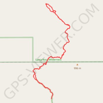
Borrego Springs - Rockhouse Canyon
Hike through the Rockhouse Canyon to the Cottonwood Springs via Rockhouse Trail, Hidden Springs, in the Santa Rosa Wilderness and the Anza-Borrego Desert State Park. #Hiking #Loop #Mountain #Canyon #Nature #Desert #Wilderness #Park
- Distance: 13.4 mi
- Elevation gain: 645 m
- Maximum elevation: 956 m
- Elevation loss: 645 m
- Minimum elevation: 496 m
- Moving time: 5 h 7 m
- Moving speed: 2.6 mph
- Maximum speed: 42.8 mph
- Total time: 5 h 31 m
- Global speed: 2.4 mph
Interactive trail map
Trail profile
- Distance: 13.4 mi
- Elevation gain: 645 m
- Maximum elevation: 956 m
- Elevation loss: 645 m
- Minimum elevation: 496 m
- Moving time: 5 h 7 m
- Moving speed: 2.6 mph
- Maximum speed: 42.8 mph
- Total time: 5 h 31 m
- Global speed: 2.4 mph
About this trail
Name: Borrego Springs - Rockhouse Canyon trail, distance, elevation, map, profile, GPS track
Start: Rockhouse Trail, San Diego County, California, United States (33.40587 -116.37535)
End: Rockhouse Trail, San Diego County, California, United States (33.40588 -116.37532)
Coordinates: 33.40587 -116.38811 33.46122 -116.36234