Make a donation
Gear up for your next adventure:
As an Amazon Associate, this site earns from qualifying purchases at no extra cost to you.
Sandia Peak Ski
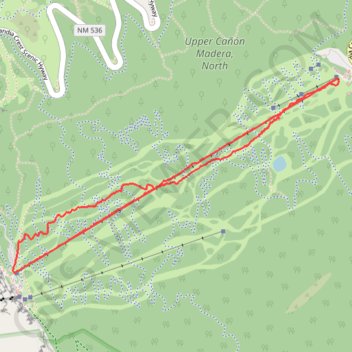
Interactive trail map
Make a donation
Gear up for your next adventure:
As an Amazon Associate, this site earns from qualifying purchases at no extra cost to you.
Trail profile
- Distance: 3.6 mi
- Elevation gain: 678 m
- Maximum elevation: 3,132 m
- Elevation loss: 480 m
- Minimum elevation: 2,651 m
- Moving time: 37 m 53 s
- Moving speed: 5.7 mph
- Maximum speed: 35.2 mph
- Total time: 39 m 5 s
- Global speed: 5.5 mph
Make a donation
Gear up for your next adventure:
As an Amazon Associate, this site earns from qualifying purchases at no extra cost to you.
About this trail
Name: Sandia Peak Ski trail, distance, elevation, map, profile, GPS track
Start: King of the Mountain, Bernalillo County, New Mexico, United States (35.20138 -106.42501)
End: Golden Eagle, Bernalillo County, New Mexico, United States (35.19738 -106.43314)
Coordinates: 35.19689 -106.43424 35.20681 -106.41388
Make a donation
Gear up for your next adventure:
As an Amazon Associate, this site earns from qualifying purchases at no extra cost to you.
Other hiking, mountain biking, running and outdoor activity trails
Click on a trail to view its statistics, map and profile.
La Luz Trail in Sandia Mountain Wilderness
United States > New Mexico > Sandoval County
The La Luz Trail is a breathtaking journey that transforms from high desert landscapes to lush pine forests as you ascend toward Sandia Peak. Hikers are treated to stunning panoramic views of Albuquerque and the surrounding mountains, especially near the scenic overlook, where wildflowers add a splash of color…
Distance: 15.4 mi • Elevation gain: 1,432 m • Maximum elevation: 3,139 m
Challenge Trail
United States > New Mexico > Bernalillo County
Distance: 14.2 mi • Elevation gain: 243 m • Maximum elevation: 3,244 m
King of the Mountain Loop Trail in Cibola National Forest
United States > New Mexico > Bernalillo County
Distance: 3.8 mi • Elevation gain: 220 m • Maximum elevation: 3,105 m
Make a donation
Gear up for your next adventure:
As an Amazon Associate, this site earns from qualifying purchases at no extra cost to you.