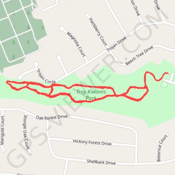
Troy Kiwanis Park main trail asphalt paved
- Distance: 3.0 mi
- Elevation gain: 30 m
- Maximum elevation: 174 m
- Elevation loss: 30 m
- Minimum elevation: 165 m
- Moving time: 54 m 22 s
- Moving speed: 3.3 mph
- Maximum speed: 5.4 mph
- Total time: 54 m 22 s
- Global speed: 3.3 mph
Interactive trail map
Trail profile
- Distance: 3.0 mi
- Elevation gain: 30 m
- Maximum elevation: 174 m
- Elevation loss: 30 m
- Minimum elevation: 165 m
- Moving time: 54 m 22 s
- Moving speed: 3.3 mph
- Maximum speed: 5.4 mph
- Total time: 54 m 22 s
- Global speed: 3.3 mph
About this trail
Name: Troy Kiwanis Park main trail asphalt paved trail, distance, elevation, map, profile, GPS track
Start: Beech Tree Drive, Troy, Lincoln County, Missouri, 63379, United States (38.97041 -90.98270)
End: Beech Tree Drive, Troy, Lincoln County, Missouri, 63379, United States (38.97041 -90.98275)
Coordinates: 38.96934 -90.99031 38.97045 -90.98270