Thank you for supporting this site ❤️
Make a donation
Make a donation
Gear up for your next adventure:
As an Amazon Associate, this site earns from qualifying purchases at no extra cost to you.
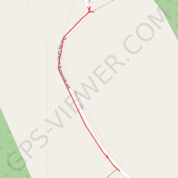
RE SK110280
- Distance: 0.3 mi
- Elevation gain: 1 m
- Maximum elevation: 155 m
- Elevation loss: 5 m
- Minimum elevation: 149 m
- Moving time: 3 m 59 s
- Moving speed: 4.5 mph
- Maximum speed: 17.4 mph
- Total time: 29 m 26 s
- Global speed: 0.6 mph
Interactive trail map
Thank you for supporting this site ❤️
Make a donation
Make a donation
Gear up for your next adventure:
As an Amazon Associate, this site earns from qualifying purchases at no extra cost to you.
Trail profile
- Distance: 0.3 mi
- Elevation gain: 1 m
- Maximum elevation: 155 m
- Elevation loss: 5 m
- Minimum elevation: 149 m
- Moving time: 3 m 59 s
- Moving speed: 4.5 mph
- Maximum speed: 17.4 mph
- Total time: 29 m 26 s
- Global speed: 0.6 mph
Thank you for supporting this site ❤️
Make a donation
Make a donation
Gear up for your next adventure:
As an Amazon Associate, this site earns from qualifying purchases at no extra cost to you.
About this trail
Name: RE SK110280 trail, distance, elevation, map, profile, GPS track
Coordinates: 52.84749 -1.84046 52.85069 -1.83849
Topography: East Staffordshire topographic map, elevation, terrain
Thank you for supporting this site ❤️
Make a donation
Make a donation
Gear up for your next adventure:
As an Amazon Associate, this site earns from qualifying purchases at no extra cost to you.