Make a donation
Gear up for your next adventure:
As an Amazon Associate, this site earns from qualifying purchases at no extra cost to you.
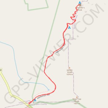
Preacher's Rock from Woody Gap via Appalachian Trail in Blood Mountain Wilderness
The hike to Preacher's Rock is a moderately challenging trek that offers an impressive payoff with its expansive views. Along the route, hikers will encounter rocky terrain, root-laden paths, and sharp switchbacks as they ascend towards the summit of Big Cedar Mountain. At Preacher's Rock, the view stretches across a vast valley with Mount Yonah and Cowrock Mountain in the distance, making it an ideal spot for a rest or picnic. #Hiking #Mountain #Overlook #Rock #Forest #Nature
- Distance: 2.0 mi
- Elevation gain: 136 m
- Maximum elevation: 1,074 m
- Elevation loss: 136 m
- Minimum elevation: 966 m
- Moving time: 47 m 7 s
- Moving speed: 2.6 mph
- Maximum speed: 5.3 mph
- Total time: 53 m 38 s
- Global speed: 2.3 mph
Interactive trail map
Make a donation
Gear up for your next adventure:
As an Amazon Associate, this site earns from qualifying purchases at no extra cost to you.
Trail profile
- Distance: 2.0 mi
- Elevation gain: 136 m
- Maximum elevation: 1,074 m
- Elevation loss: 136 m
- Minimum elevation: 966 m
- Moving time: 47 m 7 s
- Moving speed: 2.6 mph
- Maximum speed: 5.3 mph
- Total time: 53 m 38 s
- Global speed: 2.3 mph
Make a donation
Gear up for your next adventure:
As an Amazon Associate, this site earns from qualifying purchases at no extra cost to you.
About this trail
Name: Preacher's Rock from Woody Gap via Appalachian Trail in Blood Mountain Wilderness trail, distance, elevation, map, profile, GPS track
Start: Appalachian Trail, Lumpkin County, Georgia, United States (34.67775 -83.99984)
End: Appalachian Trail, Lumpkin County, Georgia, United States (34.67778 -83.99991)
Coordinates: 34.67774 -83.99991 34.68723 -83.99406
Make a donation
Gear up for your next adventure:
As an Amazon Associate, this site earns from qualifying purchases at no extra cost to you.