Crown Zellerbach Rail Trail
- Distance: 5.0 mi
- Elevation gain: 234 m
- Maximum elevation: 383 m
- Elevation loss: 234 m
- Minimum elevation: 216 m
- Moving time: 1 h 54 m
- Moving speed: 2.6 mph
- Maximum speed: 4.7 mph
- Total time: 2 h 4 m
- Global speed: 2.4 mph
Interactive trail map
Trail profile
- Distance: 5.0 mi
- Elevation gain: 234 m
- Maximum elevation: 383 m
- Elevation loss: 234 m
- Minimum elevation: 216 m
- Moving time: 1 h 54 m
- Moving speed: 2.6 mph
- Maximum speed: 4.7 mph
- Total time: 2 h 4 m
- Global speed: 2.4 mph
About this trail
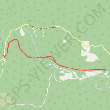
Name: Crown Zellerbach Rail Trail trail, distance, elevation, map, profile, GPS track
Start: Crown Zellerbach Rail Trail, Columbia County, Oregon, United States (45.83167 -123.04659)
End: Pisgah Lookout Road, Columbia County, Oregon, United States (45.83164 -123.04642)
Coordinates: 45.82818 -123.04659 45.83648 -123.00779
Other hiking, mountain biking, running and outdoor activity trails
Click on a trail to view its statistics, map and profile.
Ben Howard (24622956)
United States > Oregon > Multnomah County > Portland
Ben Howard (24622956)
Distance: 225.8 mi • Elevation gain: 11,851 m • Maximum elevation: 1,007 m