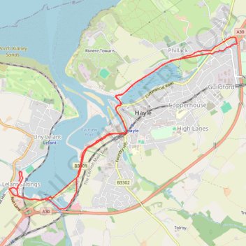
Lelant Saltings to Loggan's Moor
- Distance: 6.6 mi
- Elevation gain: 63 m
- Maximum elevation: 12 m
- Elevation loss: 62 m
- Minimum elevation: -1 m
- Moving time: 1 h 9 m
- Moving speed: 5.7 mph
- Maximum speed: 12.2 mph
- Total time: 1 h 9 m
- Global speed: 5.7 mph
Interactive trail map
Trail profile
- Distance: 6.6 mi
- Elevation gain: 63 m
- Maximum elevation: 12 m
- Elevation loss: 62 m
- Minimum elevation: -1 m
- Moving time: 1 h 9 m
- Moving speed: 5.7 mph
- Maximum speed: 12.2 mph
- Total time: 1 h 9 m
- Global speed: 5.7 mph
About this trail
Name: Lelant Saltings to Loggan's Moor trail, distance, elevation, map, profile, GPS track
Coordinates: 50.17477 -5.44460 50.19680 -5.39902
Topography: Cornwall topographic map, elevation, terrain
Other hiking, mountain biking, running and outdoor activity trails
Click on a trail to view its statistics, map and profile.
Hayle to Godrevy Point
United Kingdom > England > Cornwall > Hayle > Phillack
Distance: 13.5 mi • Elevation gain: 376 m • Maximum elevation: 61 m
St Ives to Hayle
United Kingdom > England > Cornwall > St. Ives
Distance: 10.7 mi • Elevation gain: 472 m • Maximum elevation: 60 m
Hike to Trencrom
United Kingdom > England > Cornwall > Hayle
Distance: 8.7 mi • Elevation gain: 223 m • Maximum elevation: 171 m
Run around Hayle
United Kingdom > England > Cornwall > St. Ives > Lelant Saltings
Distance: 6.4 mi • Elevation gain: 59 m • Maximum elevation: 12 m