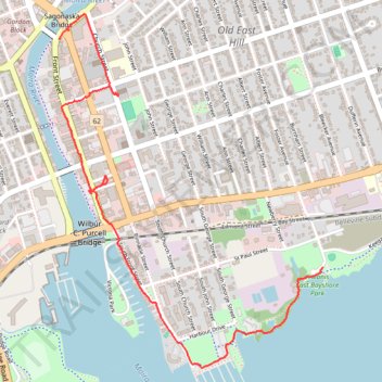
Walk - Belleville Shoreline
Canada, ON, Belleville
- Distance: 2.3 mi
- Elevation gain: 21 m
- Maximum elevation: 96 m
- Elevation loss: 24 m
- Minimum elevation: 75 m
- Moving time: 1 h 11 m
- Moving speed: 2.0 mph
- Maximum speed: 3.0 mph
- Total time: 1 h 22 m
- Global speed: 1.7 mph
Interactive trail map
Trail profile
- Distance: 2.3 mi
- Elevation gain: 21 m
- Maximum elevation: 96 m
- Elevation loss: 24 m
- Minimum elevation: 75 m
- Moving time: 1 h 11 m
- Moving speed: 2.0 mph
- Maximum speed: 3.0 mph
- Total time: 1 h 22 m
- Global speed: 1.7 mph
About this trail
Name: Walk - Belleville Shoreline trail, distance, elevation, map, profile, GPS track
End: 41, South Foster Avenue, Belleville, Central Ontario, Ontario, K8N 5G8, Canada (44.15909 -77.36933)
Coordinates: 44.15464 -77.38562 44.17027 -77.36933
Other hiking, mountain biking, running and outdoor activity trails
Click on a trail to view its statistics, map and profile.
Belleville - Kingston
Canada > Ontario > Belleville > Belleville
#Bike
Distance: 57.6 mi • Elevation gain: 394 m • Maximum elevation: 115 m
Cobourg - Belleville
Canada > Ontario > Northumberland County > Cobourg
#Bike
Distance: 50.6 mi • Elevation gain: 286 m • Maximum elevation: 118 m