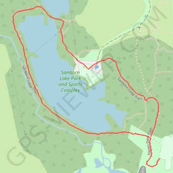
Sanborn Lake Loop Trail
Sanborn Lake Park Loop and Sports Complex
- Distance: 0.9 mi
- Elevation gain: 9 m
- Maximum elevation: 294 m
- Elevation loss: 9 m
- Minimum elevation: 286 m
- Moving time: 19 m 22 s
- Moving speed: 2.9 mph
- Maximum speed: 3.7 mph
- Total time: 23 m 57 s
- Global speed: 2.3 mph
Interactive trail map
Trail profile
- Distance: 0.9 mi
- Elevation gain: 9 m
- Maximum elevation: 294 m
- Elevation loss: 9 m
- Minimum elevation: 286 m
- Moving time: 19 m 22 s
- Moving speed: 2.9 mph
- Maximum speed: 3.7 mph
- Total time: 23 m 57 s
- Global speed: 2.3 mph
About this trail
Name: Sanborn Lake Loop Trail trail, distance, elevation, map, profile, GPS track
Start: Hazen Dam Path, Stillwater, Payne County, Oklahoma, 74075, United States (36.15337 -97.07496)
End: Hazen Dam Path, Stillwater, Payne County, Oklahoma, 74075, United States (36.15279 -97.07466)
Coordinates: 36.15258 -97.07943 36.15678 -97.07466