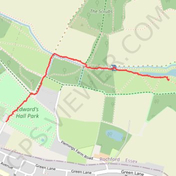
Edward's Hall Park - The Lake
Foot
- Distance: 0.9 mi
- Elevation gain: 4 m
- Maximum elevation: 44 m
- Elevation loss: 25 m
- Minimum elevation: 22 m
- Moving time: 21 m 27 s
- Moving speed: 2.4 mph
- Maximum speed: 3.8 mph
- Total time: 27 m 27 s
- Global speed: 1.9 mph
Interactive trail map
Trail profile
- Distance: 0.9 mi
- Elevation gain: 4 m
- Maximum elevation: 44 m
- Elevation loss: 25 m
- Minimum elevation: 22 m
- Moving time: 21 m 27 s
- Moving speed: 2.4 mph
- Maximum speed: 3.8 mph
- Total time: 27 m 27 s
- Global speed: 1.9 mph
About this trail
Name: Edward's Hall Park - The Lake trail, distance, elevation, map, profile, GPS track
Start: Ramblers' Millenium Walk, Rochford, Essex, England, SS9 5AE, United Kingdom (51.57563 0.64785)
Coordinates: 51.57563 0.64785 51.57947 0.66261
Topography: Essex topographic map, elevation, terrain
Other hiking, mountain biking, running and outdoor activity trails
Click on a trail to view its statistics, map and profile.
The Lake
United Kingdom > England > Essex > Rochford > Stroud Green
Foot
Distance: 0.9 mi • Elevation gain: 15 m • Maximum elevation: 32 m