Hanging Rock State Park Waterfalls
- Distance: 2.3 mi
- Elevation gain: 135 m
- Maximum elevation: 518 m
- Elevation loss: 137 m
- Minimum elevation: 422 m
- Moving time: 1 h 9 m
- Moving speed: 2.0 mph
- Maximum speed: 4.2 mph
- Total time: 1 h 23 m
- Global speed: 1.6 mph
Interactive trail map
Trail profile
- Distance: 2.3 mi
- Elevation gain: 135 m
- Maximum elevation: 518 m
- Elevation loss: 137 m
- Minimum elevation: 422 m
- Moving time: 1 h 9 m
- Moving speed: 2.0 mph
- Maximum speed: 4.2 mph
- Total time: 1 h 23 m
- Global speed: 1.6 mph
About this trail
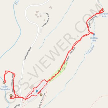
Name: Hanging Rock State Park Waterfalls trail, distance, elevation, map, profile, GPS track
Coordinates: 36.39408 -80.26923 36.40128 -80.25947
Other hiking, mountain biking, running and outdoor activity trails
Click on a trail to view its statistics, map and profile.
Hanging Rock - Wolf Rock Trail, Cole Gap Mountain, Hanging Rock Park Lake, Upper Cascades
United States > North Carolina > Stokes County
Distance: 3.8 mi • Elevation gain: 167 m • Maximum elevation: 607 m
Moores Wall Loop Trail
United States > North Carolina > Stokes County
Hanging Rock
Distance: 4.7 mi • Elevation gain: 264 m • Maximum elevation: 759 m
Hanging Rock - Moores Knob
United States > North Carolina > Stokes County
Distance: 4.2 mi • Elevation gain: 266 m • Maximum elevation: 758 m