Thank you for supporting this site ❤️
Make a donation
Make a donation
Gear up for your next adventure:
As an Amazon Associate, this site earns from qualifying purchases at no extra cost to you.
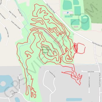
Winona Lake Trails Park MTB
bike, bicycle, mountain bike, mtb
- Distance: 10.0 mi
- Elevation gain: 72 m
- Maximum elevation: 266 m
- Elevation loss: 74 m
- Minimum elevation: 250 m
- Moving time: 1 h 19 m
- Moving speed: 7.6 mph
- Maximum speed: 20.7 mph
- Total time: 1 h 48 m
- Global speed: 5.5 mph
Interactive trail map
Thank you for supporting this site ❤️
Make a donation
Make a donation
Gear up for your next adventure:
As an Amazon Associate, this site earns from qualifying purchases at no extra cost to you.
Trail profile
- Distance: 10.0 mi
- Elevation gain: 72 m
- Maximum elevation: 266 m
- Elevation loss: 74 m
- Minimum elevation: 250 m
- Moving time: 1 h 19 m
- Moving speed: 7.6 mph
- Maximum speed: 20.7 mph
- Total time: 1 h 48 m
- Global speed: 5.5 mph
Thank you for supporting this site ❤️
Make a donation
Make a donation
Gear up for your next adventure:
As an Amazon Associate, this site earns from qualifying purchases at no extra cost to you.
About this trail
Name: Winona Lake Trails Park MTB trail, distance, elevation, map, profile, GPS track
Coordinates: 41.20945 -85.81857 41.21966 -85.80868
Thank you for supporting this site ❤️
Make a donation
Make a donation
Gear up for your next adventure:
As an Amazon Associate, this site earns from qualifying purchases at no extra cost to you.