Thank you for supporting this site ❤️
Make a donation
Make a donation
Gear up for your next adventure:
As an Amazon Associate, this site earns from qualifying purchases at no extra cost to you.
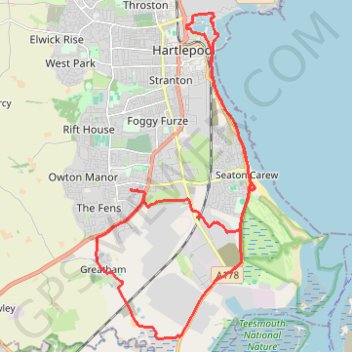
Hartlepool Bicycle
- Distance: 14.6 mi
- Elevation gain: 66 m
- Maximum elevation: 23 m
- Elevation loss: 63 m
- Minimum elevation: -1 m
- Moving time: 1 h 55 m
- Moving speed: 7.6 mph
- Maximum speed: 14.0 mph
- Total time: 1 h 58 m
- Global speed: 7.4 mph
Interactive trail map
Thank you for supporting this site ❤️
Make a donation
Make a donation
Gear up for your next adventure:
As an Amazon Associate, this site earns from qualifying purchases at no extra cost to you.
Trail profile
- Distance: 14.6 mi
- Elevation gain: 66 m
- Maximum elevation: 23 m
- Elevation loss: 63 m
- Minimum elevation: -1 m
- Moving time: 1 h 55 m
- Moving speed: 7.6 mph
- Maximum speed: 14.0 mph
- Total time: 1 h 58 m
- Global speed: 7.4 mph
Thank you for supporting this site ❤️
Make a donation
Make a donation
Gear up for your next adventure:
As an Amazon Associate, this site earns from qualifying purchases at no extra cost to you.
About this trail
Name: Hartlepool Bicycle trail, distance, elevation, map, profile, GPS track
Coordinates: 54.62692 -1.23998 54.69318 -1.18405
Topography: Hartlepool topographic map, elevation, terrain
Thank you for supporting this site ❤️
Make a donation
Make a donation
Gear up for your next adventure:
As an Amazon Associate, this site earns from qualifying purchases at no extra cost to you.
Other hiking, mountain biking, running and outdoor activity trails
Click on a trail to view its statistics, map and profile.
Hartlepool Loop
United Kingdom > England > Hartlepool
Distance: 35.0 mi • Elevation gain: 335 m • Maximum elevation: 137 m