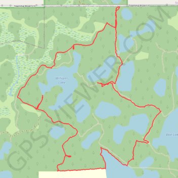
Ministik Lake Game Bird Sanctuary
Trails
- Distance: 4.5 mi
- Elevation gain: 54 m
- Maximum elevation: 774 m
- Elevation loss: 54 m
- Minimum elevation: 760 m
- Moving time: 2 h 21 m
- Moving speed: 1.9 mph
- Maximum speed: 4.6 mph
- Total time: 3 h 17 m
- Global speed: 1.4 mph
Interactive trail map
Trail profile
- Distance: 4.5 mi
- Elevation gain: 54 m
- Maximum elevation: 774 m
- Elevation loss: 54 m
- Minimum elevation: 760 m
- Moving time: 2 h 21 m
- Moving speed: 1.9 mph
- Maximum speed: 4.6 mph
- Total time: 3 h 17 m
- Global speed: 1.4 mph
About this trail
Name: Ministik Lake Game Bird Sanctuary trail, distance, elevation, map, profile, GPS track
Start: Township Road 510, Strathcona County, Alberta, Canada (53.36687 -112.96515)
End: Township Road 510, Strathcona County, Alberta, Canada (53.36684 -112.96523)
Coordinates: 53.35248 -112.98008 53.36690 -112.95887