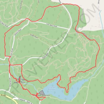
Cosgrave Reservoir - Goldfields
- Distance: 6.0 mi
- Elevation gain: 185 m
- Maximum elevation: 563 m
- Elevation loss: 186 m
- Minimum elevation: 470 m
- Moving time: 2 h 13 m
- Moving speed: 2.7 mph
- Maximum speed: 3.5 mph
- Total time: 3 h 7 m
- Global speed: 1.9 mph
Interactive trail map
Trail profile
- Distance: 6.0 mi
- Elevation gain: 185 m
- Maximum elevation: 563 m
- Elevation loss: 186 m
- Minimum elevation: 470 m
- Moving time: 2 h 13 m
- Moving speed: 2.7 mph
- Maximum speed: 3.5 mph
- Total time: 3 h 7 m
- Global speed: 1.9 mph
About this trail
Name: Cosgrave Reservoir - Goldfields trail, distance, elevation, map, profile, GPS track
Start: Creswick, Shire of Hepburn, Victoria, 3363, Australia (-37.44469 143.93615)
End: Creswick, Shire of Hepburn, Victoria, 3363, Australia (-37.44467 143.93615)
Coordinates: -37.44520 143.92696 -37.42804 143.94828
Other hiking, mountain biking, running and outdoor activity trails
Click on a trail to view its statistics, map and profile.