Wallace Falls via Woody Trail in Wallace Falls State Park
The Wallace Falls via Woody Trail offers a scenic and rewarding hike with multiple waterfall views along the way. The trail winds through lush forest, alongside the Wallace River, with bridges and benches for resting while soaking in the peaceful atmosphere. While the Middle Falls viewpoint is considered the highlight, visitors can also enjoy the cascading Lower Falls and, for those seeking a more strenuous hike, the Upper Falls offers a final, mist-filled vista. #Hiking #Waterfall #River #Forest #Nature
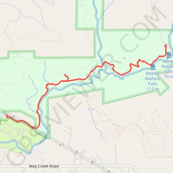
- Distance: 5.0 mi
- Elevation gain: 507 m
- Maximum elevation: 518 m
- Elevation loss: 507 m
- Minimum elevation: 102 m
Interactive trail map
Trail profile
- Distance: 5.0 mi
- Elevation gain: 507 m
- Maximum elevation: 518 m
- Elevation loss: 507 m
- Minimum elevation: 102 m
About this trail
Name: Wallace Falls via Woody Trail in Wallace Falls State Park trail, distance, elevation, map, profile, GPS track
Start: Woody Trail, Snohomish County, Washington, 98251, United States (47.86726 -121.67806)
End: Woody Trail, Snohomish County, Washington, 98251, United States (47.86726 -121.67807)
Coordinates: 47.86552 -121.67807 47.87655 -121.64650
Other hiking, mountain biking, running and outdoor activity trails
Click on a trail to view its statistics, map and profile.
Wallace Falls via Woody Trail in Wallace Falls State Park
United States > Washington > Snohomish County
Hiking the Wallace Falls via Woody Trail is an enchanting experience where you’re surrounded by towering old-growth trees and the soothing sounds of cascading water. The trail offers several breathtaking viewpoints, with the stunning Middle Falls being a must-see highlight that captures the essence of the…
Distance: 5.3 mi • Elevation gain: 429 m • Maximum elevation: 468 m
Northern part of the Pacific Crest Trail (PCT)
United States > Oregon > Klamath County
Hike on the Pacific Crest National Scenic Trail from Crater Lake to Canada Border through Oregon and Washington along the Sierra Nevada and Cascade mountain ranges. #Hiking #Mountain #SierraNevada #Cascade #Nature #Forest #Park #PCT
Distance: 744.6 mi • Elevation gain: 44,308 m • Maximum elevation: 2,307 m