Station Cove Falls via Oconee Connector Trail in Sumter National Forest
The hike to Station Cove Falls is a pleasant journey through lush Appalachian forest, offering a relatively easy and flat path. Along the route, hikers can enjoy vibrant wildflowers during the warmer months and might encounter a few charming footbridges. The highlight is the stunning tiered waterfall, which cascades impressively into a natural pool, creating a serene spot perfect for relaxation. #Hiking #Waterfall #Forest #Nature
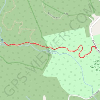
- Distance: 1.8 mi
- Elevation gain: 94 m
- Maximum elevation: 374 m
- Elevation loss: 93 m
- Minimum elevation: 320 m
- Moving time: 53 m 36 s
- Moving speed: 2.0 mph
- Maximum speed: 3.8 mph
- Total time: 1 h 7 m
- Global speed: 1.6 mph
Interactive trail map
Trail profile
- Distance: 1.8 mi
- Elevation gain: 94 m
- Maximum elevation: 374 m
- Elevation loss: 93 m
- Minimum elevation: 320 m
- Moving time: 53 m 36 s
- Moving speed: 2.0 mph
- Maximum speed: 3.8 mph
- Total time: 1 h 7 m
- Global speed: 1.6 mph
About this trail
Name: Station Cove Falls via Oconee Connector Trail in Sumter National Forest trail, distance, elevation, map, profile, GPS track
Start: Oconee Station Road, Oconee County, South Carolina, United States (34.84867 -83.07427)
End: Oconee Connector Trail, Oconee County, South Carolina, United States (34.84872 -83.07429)
Coordinates: 34.84780 -83.08558 34.84938 -83.07427