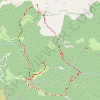
Krčmar - Reka - PEJAR 906m - KULINA 844m - Krčmar (12.09.202...
- Distance: 5.9 mi
- Elevation gain: 497 m
- Maximum elevation: 897 m
- Elevation loss: 497 m
- Minimum elevation: 504 m
- Moving time: 2 h 50 m
- Moving speed: 2.1 mph
- Maximum speed: 11.7 mph
- Total time: 4 h 27 m
- Global speed: 1.3 mph
Interactive trail map
Trail profile
- Distance: 5.9 mi
- Elevation gain: 497 m
- Maximum elevation: 897 m
- Elevation loss: 497 m
- Minimum elevation: 504 m
- Moving time: 2 h 50 m
- Moving speed: 2.1 mph
- Maximum speed: 11.7 mph
- Total time: 4 h 27 m
- Global speed: 1.3 mph
About this trail
Name: Krčmar - Reka - PEJAR 906m - KULINA 844m - Krčmar (12.09.202... trail, distance, elevation, map, profile, GPS track
Coordinates: 44.13349 19.96493 44.15343 19.98372
Other hiking, mountain biking, running and outdoor activity trails
Click on a trail to view its statistics, map and profile.
2022_Yu
Slovenia > Ajdovščina > Žapuže
Distance: 1,526.9 mi • Elevation gain: 32,048 m • Maximum elevation: 1,950 m
MALJEN Krčmar - Bela stena - Blagulja - Pejar - Kulina - Krč...
Serbia > Central Serbia > Kolubara Administrative District > Mionica Municipality > Krcmar > Тодосијевићи
Distance: 10.9 mi • Elevation gain: 823 m • Maximum elevation: 968 m