Waterfall Glen Main Trail Loop in Waterfall Glen Forest Preserve
The Waterfall Glen Main Trail Loop offers a picturesque hiking experience with a blend of wooded areas, rolling hills, and scenic views. Hikers can enjoy the tranquility of nature while spotting diverse wildlife and exploring unique geological features shaped by glacial activity. The trail's well-maintained path, which meanders near small waterfalls and through vibrant meadows, makes it suitable for outdoor enthusiasts of various skill levels. #Hiking #Loop #Forest #Waterfall #Nature
- Distance: 9.4 mi
- Elevation gain: 92 m
- Maximum elevation: 234 m
- Elevation loss: 92 m
- Minimum elevation: 183 m
- Moving time: 47 m 39 s
- Moving speed: 11.9 mph
- Maximum speed: 19.7 mph
- Total time: 47 m 39 s
- Global speed: 11.9 mph
Interactive trail map
Trail profile
- Distance: 9.4 mi
- Elevation gain: 92 m
- Maximum elevation: 234 m
- Elevation loss: 92 m
- Minimum elevation: 183 m
- Moving time: 47 m 39 s
- Moving speed: 11.9 mph
- Maximum speed: 19.7 mph
- Total time: 47 m 39 s
- Global speed: 11.9 mph
About this trail
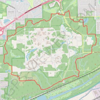
Name: Waterfall Glen Main Trail Loop in Waterfall Glen Forest Preserve trail, distance, elevation, map, profile, GPS track
Start: Northgate Road, DuPage County, Illinois, 60561, United States (41.72450 -87.97316)
End: Northgate Road, DuPage County, Illinois, 60561, United States (41.72443 -87.97320)
Coordinates: 41.69319 -88.00370 41.72557 -87.95302
Other hiking, mountain biking, running and outdoor activity trails
Click on a trail to view its statistics, map and profile.