Make a donation
Gear up for your next adventure:
As an Amazon Associate, this site earns from qualifying purchases at no extra cost to you.
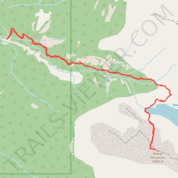
Rethel Mountain via Wedgemount Lake Trail
- Distance: 9.0 mi
- Elevation gain: 1,786 m
- Maximum elevation: 2,398 m
- Elevation loss: 1,786 m
- Minimum elevation: 749 m
- Moving time: 6 h 20 m
- Moving speed: 1.4 mph
- Maximum speed: 5.1 mph
- Total time: 11 h 15 m
- Global speed: 0.8 mph
Interactive trail map
Make a donation
Gear up for your next adventure:
As an Amazon Associate, this site earns from qualifying purchases at no extra cost to you.
Trail profile
- Distance: 9.0 mi
- Elevation gain: 1,786 m
- Maximum elevation: 2,398 m
- Elevation loss: 1,786 m
- Minimum elevation: 749 m
- Moving time: 6 h 20 m
- Moving speed: 1.4 mph
- Maximum speed: 5.1 mph
- Total time: 11 h 15 m
- Global speed: 0.8 mph
Make a donation
Gear up for your next adventure:
As an Amazon Associate, this site earns from qualifying purchases at no extra cost to you.
About this trail
Name: Rethel Mountain via Wedgemount Lake Trail trail, distance, elevation, map, profile, GPS track
Coordinates: 50.15408 -122.86323 50.17511 -122.81910
Make a donation
Gear up for your next adventure:
As an Amazon Associate, this site earns from qualifying purchases at no extra cost to you.
Other hiking, mountain biking, running and outdoor activity trails
Click on a trail to view its statistics, map and profile.
Wedgemount Lake - Wedgemount Glacier
Canada > British Columbia > Squamish-Lillooet Regional District > Area C (Pemberton Valley/Mount Currie/D'Arcy)
Garibaldi Provincial Park. #Hiking #Wedgemount #Garibaldi
Distance: 9.3 mi • Elevation gain: 1,389 m • Maximum elevation: 1,949 m
Path Segment 1
Canada > British Columbia > Squamish-Lillooet Regional District > Area C (Pemberton Valley/Mount Currie/D'Arcy)
Distance: 2.2 mi • Elevation gain: 984 m • Maximum elevation: 1,760 m
Make a donation
Gear up for your next adventure:
As an Amazon Associate, this site earns from qualifying purchases at no extra cost to you.