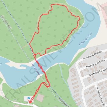
Petawawa River
- Distance: 0.8 mi
- Elevation gain: 13 m
- Maximum elevation: 141 m
- Elevation loss: 12 m
- Minimum elevation: 130 m
- Moving time: 23 m 29 s
- Moving speed: 2.0 mph
- Maximum speed: 4.4 mph
- Total time: 25 m 5 s
- Global speed: 1.8 mph
Interactive trail map
Trail profile
- Distance: 0.8 mi
- Elevation gain: 13 m
- Maximum elevation: 141 m
- Elevation loss: 12 m
- Minimum elevation: 130 m
- Moving time: 23 m 29 s
- Moving speed: 2.0 mph
- Maximum speed: 4.4 mph
- Total time: 25 m 5 s
- Global speed: 1.8 mph
About this trail
Name: Petawawa River trail, distance, elevation, map, profile, GPS track
Coordinates: 45.89880 -77.28932 45.90218 -77.28679
Other hiking, mountain biking, running and outdoor activity trails
Click on a trail to view its statistics, map and profile.